
Rurbanisation: The Example Of Metz, France (1/2)
In my article of August 13th, 2019, I showed that Metz had assets in the three economic sectors: agriculture (in particular cereals and livestock), advanced industry (notably in automobile) and services (research, consulting , tourism, culture) [1]de FOUCAULD Bertrand, The Agglomeration Of Metz: Why So Many Underexploited Assets? Available at: https://contrib.city/index.php/en/2019/08/26/metz-agglomeration-france-why-so-many-underexploited-assets/. As such, the outskirts of Metz play a vital role in the urban area by providing the necessary resources for the daily life of the latter.
(Cover photo: view of the village of Failly, located just outside the north-eastern periphery of Metz-Métropole taken from the former German railway line, upstream and north of the village. BdF, August 24, 2019).
What is rurbanity?
Today, we will approach the furthest part of the urban zone, that of the rurban area. But what does rurban mean? Resulting from the fusion between the words rural and urban, this term means a territory that has kept a rural aspect, with the presence of fields for example, but partly inhabited, and in a growing way, by households exercising an activity in the city, therefore in the secondary (industry) or tertiary (services) sectors [2]As a reminder, an accountant, even if he works for the Ministry of Agriculture, is employed in the service sector, thus in the tertiary sector. At the national level, persons with jobs in the agricultural sector (in the broad sense of the term) accounted for 2.8% of the French labor force in 2014 [3]INSEE, Population en emploi selon le sexe et le secteur d’activité (Employed population by gender and sector of activity), 1st March 2016, [visited on 2nd September 2019]. Available at: https://www.insee.fr/en/statistiques/1906677?sommaire=1906743, with a number of farms which has dropped by more than half between 1993 and 2013, and with the [large farms] average area now exceeding 100 hectares [4]INSEE, Exploitations agricoles (Farms), 20th February 2013, [read on the 2nd of September 2019]. Available at: https://www.insee.fr/fr/statistiques/1374189?sommaire=1374192.
The Assets Of Those Territories
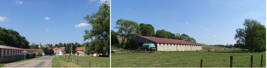
These rural areas have many advantages in terms of living environment. In the regional cities, and especially in Metz, countryside can be reached in 20 minutes, by car, from the city center, with a smooth traffic (30 minutes in rush hour) [5]to compare with 45 minutes minimum to reach a rural territory, beyond Saint-Germain-en-Laye in the west or Marne-la-Vallée in the east, from Notre-Dame-de-Paris, in Ile-de-France Region. The cost of real estate, in these rural areas close to the urban area of Metz, is particularly interesting for young households who start both their professional and family life. Even if the market value of a field (calculated per hectare) can be multiplied up to 50 [6]or more if it is made constructable by the mayor – and in this case the price of this land not won’t any longer be estimated per hectare but per square meter, that is to say, according to a surface unit 10,000 times smaller, a strong sign of the change of function and price of this parcel – this land which has become constructible will nevertheless represent a financial and real estate opportunity: a young couple can build or buy a larger dwelling than in downtown. This dwelling will usually be a house with garden, in a “green” environment, with perhaps a little river passing in the vicinity, as the stream north of Failly flowing from the pond below the Bois de Monsieur and Bois Driat east of the village, or as the creek of Quarante which crosses Nouilly.
The promoters have understood these mechanisms and, through meetings with elected officials notably at fairs, look for opportunities: agricultural lands that will soon be registered, in the local Master Plan, no longer as a rural zone but as an urban area. These real estate developers do not only employ construction workers (from countries within or outside the European Union) to develop these land (roads and fluids distribution) but also architecture and /or urban planning, engineering consultancies and participate in the creation of commercial zones to supply young newly arrived households who take advantage of those equipment to give birth to children. All of this participates into creating a real economic tissue. These municipalities, having seen their urban zone growing, first of all by the sprawl [7]The sprawl of the rural space consists in the a little anarchic establishment of houses. The arrival of urban planning rules may eventually slow down or stop the construction on the concerned area but will also move the trend further away to the periphery and by the unification of the built plots (streets, houses, apartments, administrations, offices, public works of art such as water castles), while that of the main city of the metropolis (the first being most often located in the center of the latter) also widened and joined the urban area of the village became suburban city, before being administratively integrated in the long term by the main town, like the district of Plantières-Queuleu, located in the eastern part of Metz: Plantières was formerly an independent town, which was attached in 1789 to Queuleu (known for its fortress), before integrating the metropolis in 1908 [8]TOUT METZ, “District Plantières-Queuleu Metz” in The District of the city of Metz, 2010-2011, [seen 03 / 09/2019]. Available on: https://tout-metz.com/quartiers/metz-plantieres-queuleu.
These territories, with both urban and rural features, are sometimes home to cultural and/or tourist attractions that bring a particular character to the place. As an example, the villages of Failly and Nouilly still have remains of the German railway line: the former path and the beginning of a viaduct at Failly and a tunnel in Nouilly (the longest in the region ). These historical remains remind inhabitants and visitors of the history of this area and could possibly serve as a starting point for a theme circuit on the Germanic contributions, in terms of construction, to the Alsace-Lorraine Region.
Risks For The Metropolitan Area
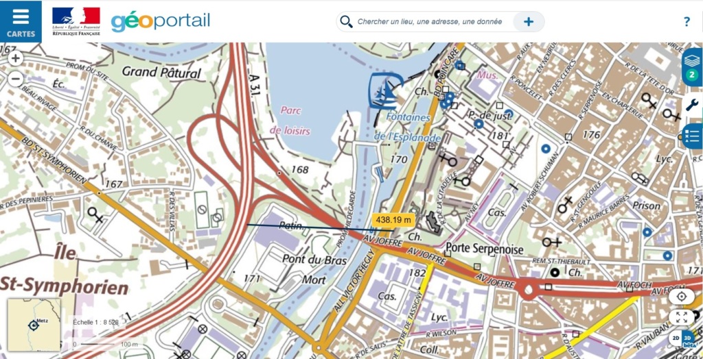
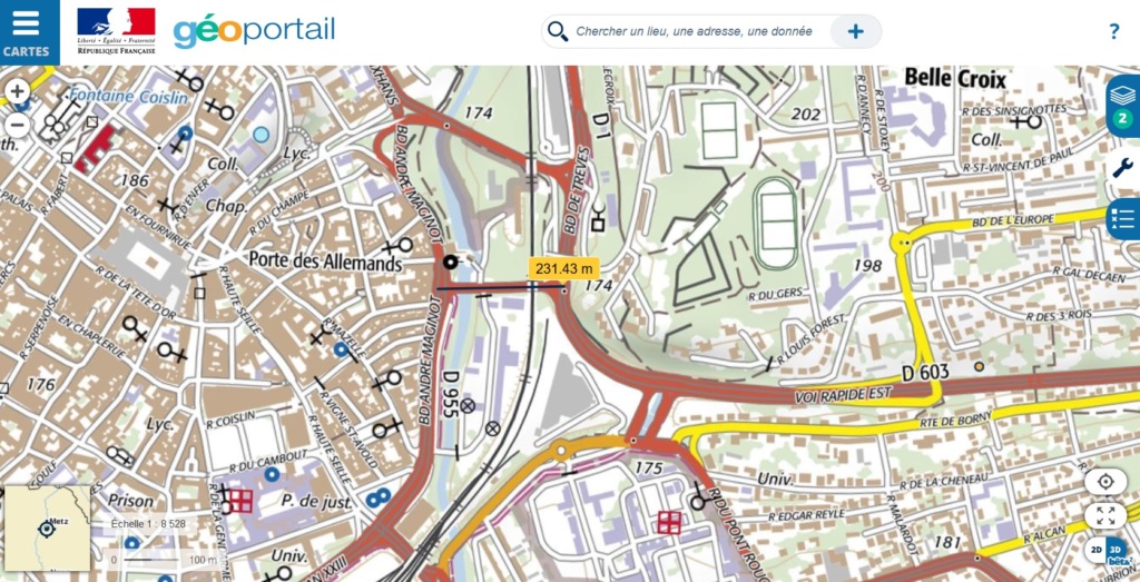
But beware! Living conditions and environment are two different things: a place can offer pleasant living conditions while presenting pollution issues. In this respect, on the long-term, rurban areas can increase emissions of greenhouse gases (CO2) and / or pollutants (CO). They see their traffic increase and thus encourage the construction of new roads or highways to connect these areas to the peri-urban crown, or even to downtown. Thus, north of the island where Fort Moselle is located, motorists coming from the west of Metz can park for free (if they have a subscription to the Metz public transports) on the car park located between the Eblé and Jean-Monnet bridges. But one can also take the A31 highway that crosses the city by a South-East / North loop and passes at less than 500 m, as the crow flies, from the very dense medieval city center. Similarly, the Eastern expressway that extends the A314 highway (East of Metz), passes at less than 250m from the Porte des Allemands, that is to say the eastern entrance of the old town.
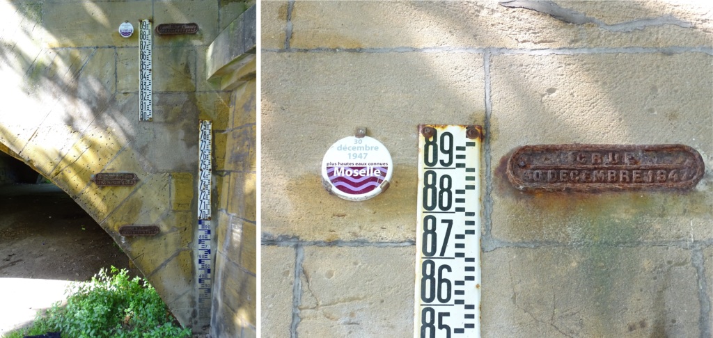
The other consequence of the rurbanisation of the territories: the sprawl of constructed areas in the countryside which surrounding the metropolis inexorably leads to the urbanization of these rural areas. This urbanization leads to the artificialization of land, through the construction of roads and buildings, and therefore an increase in the risk of major flooding for areas located near rivers. As a reminder, a vegetated land will absorb some of the precipitation and therefore will curb the overflow of the stream below. A paved road, or an allotment, will accelerate the evacuation of rain to the creek or river of the local watershed. At the scale of the metropolis, it is the center of Metz, located on the Moselle which is most at risk: catastrophic floods punctuate the history of the city. Global warming and urban sprawl contribute to increase not only the frequency of these floods but also their strength. The level of the highest known waters in Metz is likely to increase in the coming decade. The construction of dams or dikes provides a respite only to the extent that the flood remains average. In the case of an exceptional flood, these public facilities can be counterproductive by holding back water while the water level has already begun to drop [10]cf : de FOUCAULD Bertrand, Urbanisation And Floods (London & Paris), 6th July 2019. Available at: https://contrib.city/index.php/en/2019/07/06/urbanisation-and-the-fluvial-risk-factor/.
Additional bibliography [11]METZ, Berges du plan d’eau, [vu le 4 septembre 2019]. Disponible sur : https://metz.fr/lieux/lieu-963.php.[12]METROPOLE DE METZ, “Quartier de Borny à Metz” in Tout Metz – Actualités régionales & agenda, le 5 septembre 2019, [vu le 5 septembre 2019]. Disponible sur : https://tout-metz.com/quartiers/metz-borny.[13]MELCHIOR, Croissance zéro et la décroissance, [vu le 5 septembre 2019]. Disponible sur : https://www.melchior.fr/notion/la-croissance-zero-et-la-decroissance.[14]INSEE, “Metz-Métropole perd des habitants entre 2010 et 2015, du fait d’une faible attractivité résidentielle” in Dossier Grand Est n° 9, août 2018, [vu le 4 septembre 2019]. Disponible sur : https://www.insee.fr/fr/statistiques/3600178?sommaire=3600210.[15]MERLIN Pierre, Les grands ensembles, Paris, La Documentation française, 2010, 209p.[16]BAUD Pascal, BOURGEAT Serge et BRAS Catherine, Dictionnaire de géographie, Paris, Hatier, 2003, 544 p.[17]GEORGE Pierre, VERGER Fernand, Dictionnaire de la géographie. 8e éd, Paris, PUF, 2004, 462 p.[18]DAUPHINE André, Risques et catastrophes – Observer, spatialiser, comprendre, gérer, Paris, Armand Colin, 2005, 288p.[19]SALOMON Jean-Noël, L’Homme face aux crues et aux inondations, Bordeaux, Presses universitaires de Bordeaux, 1997, 136 p.[20]LAZARO Timothy, Urban hydrology: a multidisciplinary perspective. (revised edition), USA, Technomic Publishing Co, 1990, 243 p.[21]GRAFMEYER Yves, Sociologie urbaine, S.l., Armand Colin, 2005, 128 p.
[mapsmarker marker=”34″]
Références