
Urbanisation And Floods (London & Paris) – Re-ed.
Contrib’City is publishing a new edition of its July 6th 2019 article, on the issue of floods and, by extension, on the vulnerability of megalopolises facing so-called “natural” risks. In doing that, Contrib’City just follows April 28th and March 27th, 2020, articles [1]https://contrib.city/index.php/en/2020/04/28/louis-xiv-coronavirus-ecb-3-7-centralisation-health-vulnerability/ and https://contrib.city/index.php/en/2020/03/27/ms-hidalgo-containment-and-urban-density/.
This week, in France, the municipal councils which were elected in the first round will choose their mayors. Crucial decisions will then be taken in terms of planning[2]In France, the mayor has a strong local power, as for example, the urban planning one., in a context where very strong tensions exist. In agglomerations like those of Paris or London, when a non-constructible land – for example because of its flooding character – is suddenly declared constructible, its property value can be multiplied by 50 folds! Imagine a trader who can sell his products with a 5000% margin: no store manager would even dare to dream about that. In the Real Estate market, it is possible, at least for the municipalities. Tensions in this market encourage local authorities to extend their building areas and to build housing – or offices and commercial areas – as well as the (peri)urban infrastructures connecting these, on former floodplains. However, the urban extension of Paris and London Regions increases the vulnerability of these two agglomerations, particularly vis-à-vis floods, whether in material (Ile-de-France) or human (London) terms.
The creation of flood control equipment, decided by the public authorities, brings a false sense of security to the inhabitants. These areas could well be flooded again, with all the socio-economic and human consequences that this would imply in the event of a major flood, such as that of Paris in 1910 or that of London in 1928. It is interesting to know that in the 17th century , the Seine and the Thames were much wider than today [3]the width of the Thames was three times that of today. The narrowing of these two river beds led to an increase in their hydraulic pressures which can become catastrophic during exceptional precipitations.
Finally, in the talweg [4]German term for the valley bottom line, that is to say that of water collection of the Ile-de-France valleys such as those of Bièvre or Chevreuse, the river can take, after one or more thunderstorm rains, a torrential character. To this must be added the lateral watercourses, that is to say the runoff from the hillsides [5]see: “Altimetric section of the Bièvre valley” in Floods and joint risks: who pays and who benefits? (full edition), May 12, 2020. Available at: https://contrib.city/index.php/en/2020/05/12/floods-and-joint-risks-who-pays-and-who-benefits-full-edition/.
Dear Contrib’Citizen, if you want more details, you can click on one of the links below. You will have access to the development of the points mentioned above during several international conferences, such as the ones organized by the 3rd World Planning Schools Congress, in Perth (Autralia), in 2011 or by the EUROGEO association in Malaga (Spain) in 2016 (https://www.eurogeography.eu/).
Lire plus : Fluvial risk factor calculation or https://www.academia.edu/10449855/Urbanisation_and_the_fluvial_risk_factor
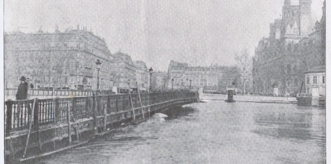
(Cover photo de couverture: the Arcole Bridge, next to the Paris City Hall, on the background on the right, during the peak of the Seine flood in 1910)
Added Bibliography[6]BFMTV, Crue de l’Yvette : une rivière s’est formée dans les rues d’Orsay – Témoins BFMTV, le 1er juin 2016. [Consulté le 19 mai 2020], disponible sur : https://temoins.bfmtv.com/mediaplayer/video/crue-de-l-yvette-une-riviere-s-est-formee-dans-les-rues-d-orsay-temoins-bfmtv-825162.html[7]SIAHVY, Gestion des inondations, Le SIAHVY investit pour la protection des riverains. [Consulté le 19 mai 2020], disponible sur : https://www.siahvy.org/nos-competences/gestion-inondations[8]https://www.geoportail.gouv.fr/carte
Références
Thanks Bertrand for the insights.